
For everyone in or on the water
Underwater visibility forecast

Viziato forecasts underwater visibility, for coastal waters and the open ocean, updated every day. It shows the expected visibility, in feet or meters, at any point on the map, with a 9-day forecast, so trips can be planned around the clearest water.


Today’s forecast map is free. Exact visibility, the full 9-day forecast and visibility alerts require Viziato Pro, which offers a one-week free trial on the yearly plan.
Every day more than 3.7 billion values of currents, waves, tides, wind, weather and sunlight are turned into one forecast map of more than 18 million ocean cells.
During development, the forecast was checked against real dives by the Viziato team and field testers.
Try the map
Nine days of South Florida and the Bahamas
A rendering of Viziato’s nine-day forecast. Move across the water, or tap it, to read the visibility in feet or meters, and play through the days. In the app the forecast is updated every day, anywhere from 60° N to 60° S.
Loading the map…
—ft
LoadingDay 1
Why Viziato
Built for one job: underwater visibility.
Viziato is not trying to be everything for everyone. It does one thing and keeps it simple: how far you can see underwater, anywhere on the map, with a 9-day forecast. One clear number, from a deep neural network built for that job alone.
9-day forecast Pro
The forecast for 9 days at any point on the map.
Any point on the map
Rated from Very Poor to Outstanding. Pro shows the exact feet or meters.
850+ dive sites
Popular boat dives worldwide, pinned on the map. See the list.
Daily Top 10
The ten clearest of the included dive sites, ranked every day.
Saved spots
Saved with a tap, or typed in as coordinates.
Visibility alerts Pro
A notification when a saved spot reaches the visibility set for it.
Custom map colors Pro
Set the color scale to suit local water.
GPX import and export Pro
Spots to and from a chartplotter as a GPX file.
Offline access Pro
The last downloaded forecast opens with no signal.
3D globe
The forecast on a globe that turns, zooms and tilts toward the horizon. Tap the water for a reading.
Widgets
Home Screen and Lock Screen widgets for one saved spot, or cycling through them.
Share cards
A forecast card as a post or a story, or a short video of the map zooming in and the nine days.
How it works
How far you can see, for nine days
Viziato forecasts horizontal visibility: the distance a diver sees across the water before a dark object fades from view. One clear number, in feet or meters, for every ocean cell from 60° N to 60° S.
What makes it different. Satellite visibility maps show Secchi depth: how deep a white disk can be seen looking straight down. A diver looks across the water, and that distance is different. The gap changes with the water’s clarity. A satellite also needs clear sky. Viziato forecasts the distance a diver sees, with a 9-day forecast.
-
Data
Each day Viziato takes in a multitude of data sets. Things like ocean currents, temperature, salinity, waves, wind, weather, sunlight, haze, tides, biological activity, the seafloor, the coastline and more than a million river mouths, to name some.
-
Model
The forecast comes from a deep neural network built for one job, underwater visibility. It is the same kind of algorithm behind the AI hurricane models the National Hurricane Center now uses. It learned from decades of ocean and atmospheric data: 772 billion values. Every day it performs 23.5 quadrillion calculations to generate its forecast.
-
Forecast
The result is horizontal visibility across more than 18 million ocean cells, covering the world’s oceans from 60° N to 60° S, updated daily: nearly 184 million forecast values a day. The app shows one clear figure in feet or meters.
- More than 18 million
- ocean cells, for nine days
- Nearly 184 million
- forecast values a day
- 772 billion
- values of ocean and atmospheric data it learned from
- 23.5 quadrillion
- calculations, every day
- More than 28 million
- parameters
- Nearly 3 million
- data points behind every forecast
Saved spots stay private.
The app downloads the whole forecast map and works out every reading on the phone itself. Saved spots, the points read on the map and the phone’s location are never sent to VIZIATO LLC or anyone else. Spots are backed up only to the user’s own cloud account, and they leave the phone only when the user exports or shares them.
The data sources are listed with their licenses and DOIs on the Data page. Sources for the comparison: Zaneveld and Pegau 2003, “Robust underwater visibility parameter”, Optics Express 11; Lee et al. 2015, Secchi disk depth theory; IOCCG lecture on Secchi depth.
Limitations. The forecast describes near-surface water. Forecasts are estimates and can differ from conditions on site. Viziato is not a navigation or safety tool.
Viziato and Viziato Pro
Free for today. Pro for all nine days.
The forecast map, the conditions at any point, the dive sites and the daily Top 10 are free. Viziato Pro adds the exact numbers, all nine days and the tools for planning a trip.
| ViziatoFree | Viziato ProMonthly or yearly | |
|---|---|---|
| The forecast | ||
| Forecast mapAnywhere from 60° N to 60° S | Today | All 9 days |
| Conditions at any point | Rated Very Poor to Outstanding | 28ftExact, in feet or meters |
| Dive sites | ||
| Popular boat dive sites on the mapMore than 850 | Included | Included |
| Daily Top 10The clearest of the included sites, with their visibility | Included | Included |
| Saved spots | Included | Included |
| Visibility alertsWhen a saved spot reaches the visibility set for it | —Not included | Included |
| On the boat | ||
| Offline accessThe last downloaded forecast opens with no signal | —Not included | Included |
| GPX import and exportSpots to and from a chartplotter | —Not included | Included |
| Custom range for the map colors | —Not included | Included |
The yearly plan starts with a one-week free trial for accounts that have not used one before. The trial becomes a paid yearly subscription unless it is canceled at least 24 hours before it ends.
Labs
What we’re testing next
Early versions of what comes after the app. They are still being built, so they can change before they are finished.
-
Beta · Viziato 1.2
Trend map
Hexagons over the water show where it is getting clearer or murkier between today and a later day. Each hexagon is the average of the water inside it, from about 7 to 110 miles across, and stays in place as the map zooms.
Coming to Viziato Pro in version 1.2.
-
 Beta
Viziato Wall
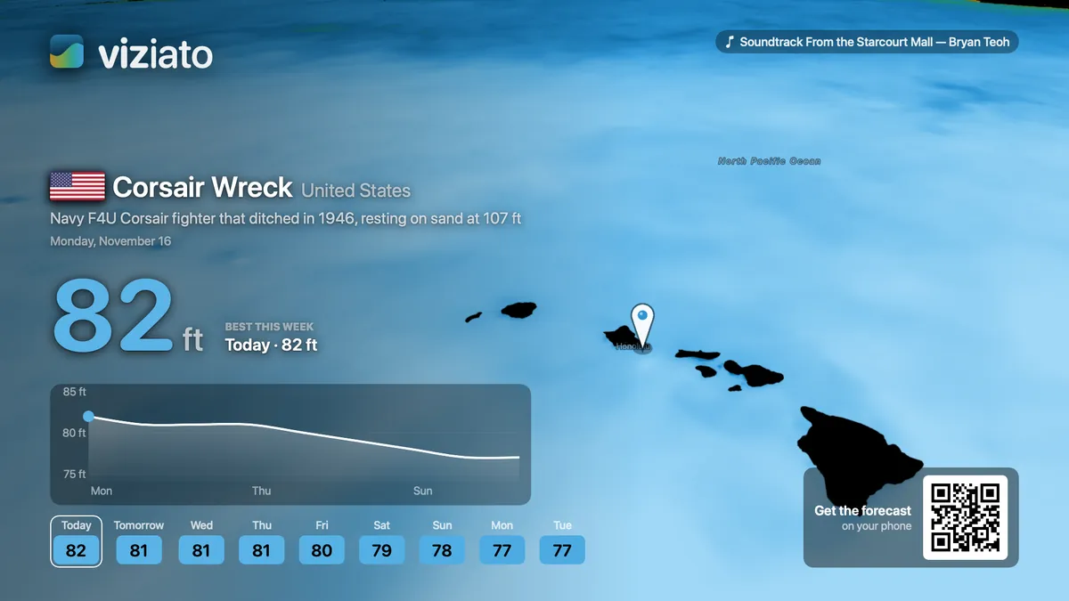
The forecast as a slow flyover from one dive site to the next, with the nine days at each. Made for a TV in a dive shop, on a boat or at home.
Apple TV and Mac first, then Windows and Android TV.
-
Coming soon
Viziato API
The same forecast inside your own app or website: visibility at any point, the 9-day forecast and map tiles. For dive shops, charter and booking sites, and marine apps.